


404
+1-313-307-4176
Geographic Information System Market Growth Analysis | 2023-2028

Geographic Information System Market Size, Share, Trends, Dynamics, Forecast, & Growth Analysis: 2023-2028
The geographic information system market was estimated at USD 10.91 billion in 2022 and is likely to grow at a CAGR of 12.4% during 2023-2028 to reach USD 22.11 billion in 2028.
_77742.webp)
Wish to get a free sample? Register Here
A Geographic Information System is defined as a computer system that is employed to capture, store, and present geographic information. It fuses the spatial data including location mainly map and satellite with attribute data including demographic or land use information. GIS enables users quickly to explore, analyze, and make sense of the data and how it is related to offering solutions.
It is used broadly in different areas such as land use planning, management, environment, transport, disaster, and emergencies. Some of the activities that GIS supports include mapping as well as spatial analysis, modeling, and decision-making since it provides tools for data manipulation, query, and visualization. Organizations can make proper decisions and find the proper solution to spatial problems by getting help from location-based data.
The geographic information system market is experiencing remarkable growth, driven by several key factors:

Want to get more details about the drivers? Register Here
The market is highly populated with the presence of several local, regional, and global players. Most of the major players compete in some of the governing factors including price, product offerings, regional presence, etc.
The following are the key players in the geographic information system market (arranged alphabetically).
Note: The above list does not necessarily include all the top players in the market.
Are you the leading player in this market? We would love to include your name. Write to us at [email protected]
|
Segmentations |
List of Sub-Segments |
Dominant and Fastest-Growing Segments |
|
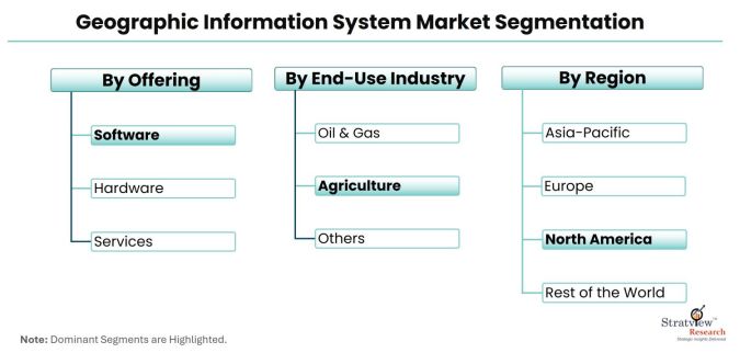
Offering Type |
Hardware (Total Stations, GIS Collectors, GNSS/GPS Antennas, LiDAR, and Imaging Sensors), Software (Desktop GIS, Mobile GIS, GIS Server and Web GIS, Developer GIS, and Remote Sensing Software), and Services |
The software segment accounts for the highest growth during the forecast period. |
|
End-Use Industry Type |
Agriculture, Oil & Gas, Building & Construction, Transportation, Utilities, Government, Healthcare, Retail, and Others |
The agriculture segment accounts for the highest growth during the forecast period. |
|
Region Analysis |
North America, Europe, Asia-Pacific, and the Rest of the World |
North America is estimated to be the largest market where as Asia-Pacific will be the highest growth during the forecast period. |
“The software segment accounts for the highest growth during the forecast period.”
The geographic information system market is segmented into hardware, software, and services. The hardware segment is further bifurcated into GIS collectors, imaging sensors, LiDAR, total stations, and GNSS/GPS antennas. The software segment is similarly bifurcated into desktop GIS, Server GIS, developer GIS, mobile GIS, and remote sensing software. The software segment is estimated to register the highest growth during the forecast period. Increasing use of GIS in urban planning, disaster management, transport management, and smart city development are the major factors contributing towards the growth of the segment.
“The agriculture segment accounts for the highest growth during the forecast period.”
The market is segmented as agriculture, oil & gas, building & construction, transportation, utilities, mining, government, healthcare, retail, and others. The agriculture segment is expected to witness the highest growth during the forecast period. There is increasing demand for GIS in the agriculture industry for livestock monitoring, crop management, and the monitoring and management of soil and irrigation of farmlands.
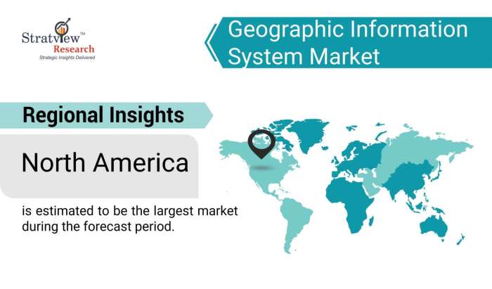
“North America is estimated to be the largest market during the forecast period.”
Significant demand from the various end-use industries and the presence of major players in the region are the major factors behind the dominance of the region in the global geographic information system market.
Asia-Pacific is estimated to portray the highest growth during the forecast period. China, Japan, South Korea, and India are the driving forces of the region’s market.
Want to know which region offers the best growth opportunities? Register Here
This strategic assessment report, from Stratview Research, provides a comprehensive analysis that reflects today’s geographic information system market realities and future market possibilities for the forecast period of 2023 to 2028. After a continuous interest in our geographic information system market report from the industry stakeholders, we have tried to further accentuate our research scope to the geographic information system market to provide the most crystal-clear picture of the market. The report segments and analyzes the market in the most detailed manner to provide a panoramic view of the market. The vital data/information provided in the report can play a crucial role for the market participants as well as investors in the identification of the low-hanging fruits available in the market as well as in formulating the growth strategies to expedite their growth process.
This report offers high-quality insights and is the outcome of a detailed research methodology comprising extensive secondary research, rigorous primary interviews with industry stakeholders, and validation and triangulation with Stratview Research’s internal database and statistical tools. More than 1000 authenticated secondary sources, such as company annual reports, fact books, press releases, journals, investor presentations, white papers, patents, and articles, have been leveraged to gather the data. We conducted more than 15 detailed primary interviews with the market players across the value chain in all four regions and industry experts to obtain both qualitative and quantitative insights.
This report provides market intelligence in the most comprehensive way. The report structure has been kept such that it offers maximum business value. It provides critical insights into market dynamics and will enable strategic decision-making for existing market players as well as those willing to enter the market. The following are the key features of the report:
This report studies the market, covering a period of 12 years of trend and forecast. The report provides detailed insights into the market dynamics to enable informed business decision-making and growth strategy formulation based on the opportunities present in the market.
The geographic information system market is segmented into the following categories:
By Offering Type
By Function Type
By End-Use Industry Type
By Region
Click Here, to learn the market segmentation details.
With this detailed report, Stratview Research offers one of the following free customization options to our respectable clients:
Company Profiling
Competitive Benchmarking
Custom Research: Stratview Research offers custom research services across sectors. In case of any custom research requirements related to market assessment, competitive benchmarking, sourcing and procurement, target screening, and others, please send your inquiry to [email protected].
A Geographic Information System is defined as a computer system that is employed to capture, store, and present geographic information. It fuses the spatial data, including location, mainly on the map and satellite, with attribute data, including demographic or land use information. GIS enables users quickly to explore, analyze, and make sense of the data and how it is related to offering solutions. It is used broadly in different areas such as land use planning, management, environment, transport, disaster, and emergencies. Some of the activities that GIS supports include mapping as well as spatial analysis, modeling, and decision-making since it provides tools for data manipulation, query, and visualization.
The geographic information system market was estimated at USD 10.91 billion in 2022.
The geographic information system market is likely to reach USD 22.11 billion in 2028.
The geographic information system market is likely to grow at a CAGR of 12.4% during 2023-2028.
Environmental Systems Research Institute, Inc., Hexagon AB, Pitney Bowes Inc., Autodesk Inc., Trimble Inc., Topcon Corporation, Hi-Target Surveying Instrument Co. Ltd., Bentley Systems Inc., Caliper Corporation, Computer Aided Development Corporation Ltd., SuperMap Software Co., Harris Corporation, and Maxar Technologies Inc are among the key players in the market.
North America is expected to be the largest market during the next five years.
The software segment is estimated to register the highest growth during the forecast period.
The agriculture segment is expected to witness the highest growth in the arket in the coming years.


WE ACCEPT


